

New APRS Digipeater Now In Service Atop Pine Mountain Outside Of Whitesburg, KY
APRS stands for Automatic Packet Reporting System. It’s a digital communication protocol used primarily by amateur radio operators to exchange real-time data over radio frequencies. APRS combines GPS (Global Positioning System) technology with packet radio to provide a way to track and display the location of vehicles, objects, or individuals on a map.
The APRS system enables the transmission of various types of information, including GPS coordinates, weather reports, messages, announcements, telemetry data, and more. The data is typically transmitted in small packets and can be received by other APRS-equipped devices within range. These packets can then be displayed on a map or shared with other APRS users.
The APRS system operates on several frequencies, depending on the region and the band used by amateur radio operators. The most commonly used APRS frequency is 144.390 MHz in the 2-meter band. This frequency is widely adopted in North America and many other parts of the world.
Additionally, APRS can be accessed through the internet using the APRS-IS (APRS Internet Service). This allows APRS data to be transmitted and received globally, providing a wide range of coverage beyond the limitations of traditional radio communications.
Whitesburg APRS Node Info
- Frequency 144.390
- Call Sign is AF4Y-10
- Radio is a TM-V71A (yes a bit of over kill for the purpose but it was laying the shack dormant)
- Running APRSIS32 as the APRS brain
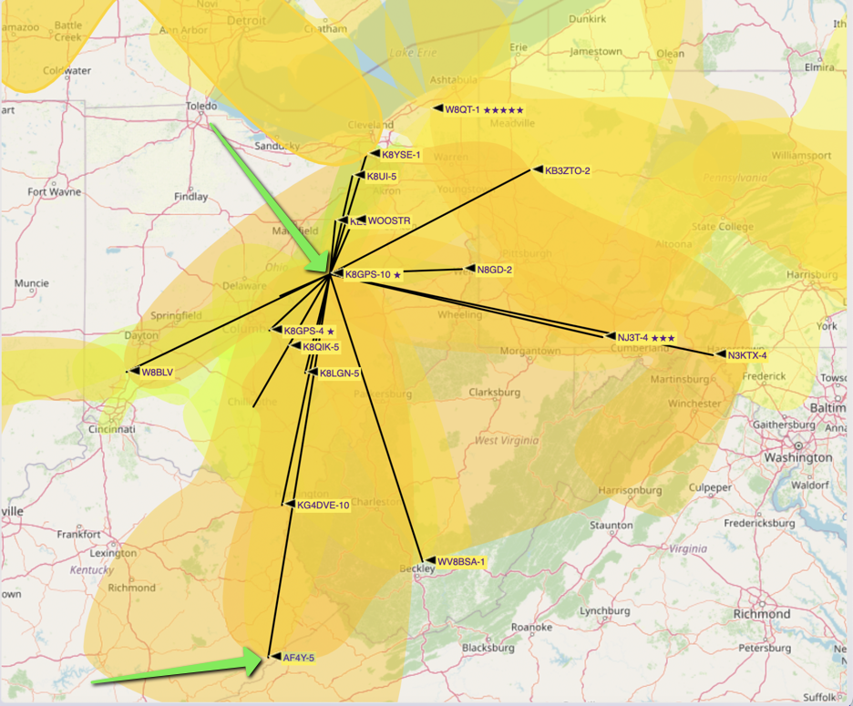
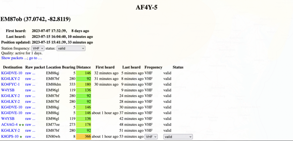
One other great benefit of having this node atop Kentucky’s second highest mountain is knowing if there is a 2m band opening. APRS data is fed to https://vhf.dxview.org/#. From here you can see what other digipeaters are hearing AF4Y-10. As an example on July 15th AF4Y-10 (then operating as AF4Y-5) was heard by K8GPS-10 in Columbus, Ohio. (NOTE: distance is in kilometers not miles, in miles that is roughly 288 miles)
For more information on APRS and some of the things you can use it for, please enjoy this presentation from the Fayette County Amateur Radio Club in Georgia. Also a special thanks to Tim Webb KK4WH for his help in getting the digipeater up and going.
Will A Buried Dipole Work?
An Excellent Free Solution For Logging Your QSOs As Well As Controlling Your Radio And Some Accessories
I suggest Log4OM as an excellent free piece of software. This is made for Windows, so it is not for Mac or Linux, unless you know how to install and setup Wine. Some of the features:
- Accurate call sign lookup data. 6 different sources of data.
- Award tracking and display fully configurable by the user. 40+ awards configured and growing.
- Band mapping of cluster spots with multiple band viewers individually filtered by mode and band by the user.
- Call lookup by multiple external sources QRZ, HamQTH, QRZCQ, HamCall and internal Clublog aggregated with automatic fallback to secondary source if primary contains no data
- Call sign online QSL graphics and large scale
- Scrollable location map displays up to the street level. Where are you on my map?
- Propagation analysis using VOACAP linked to call sign lookup and cluster which predicts probability of a connection (Contact)
- Dynamic UDP inbound / outbound support over multiple ports and services. You probably will never reach the limit of our integration engine.
- NET control interface
- Lazy Log fast logging interface
- Ease of use via mouse or keyboard. Because 2 hands are not enough.
- Enhanced standalone contest support with integral CAT display.
- Expanded Winkeyer support with integral CAT display.
- Full management of confirmations of the QSO data is available with different methods of delivery of the most appropriate confirmation type, including merging of QSO confirmation data.
- Full SOTA & IOTA support, along of many other.
- Fully integrated with LOTW, eQSL, QRZ.com, HamCall, Clublog, HamQTH, HRDlog.net etc.
- Improved QSO search engine with support for complex queries without SQL knowledge requirements (AND, OR, nested conditions). You can explore your database at byte level.
- Integration with N1MM, PSTRotator, QARTest, WSJT-x, JTDX, JTAlert and FLDigi
- Our superior Intelligent cluster aggregates the information from multiple cluster servers and HRDLog Super cluster with spot quality display.
- Intelligent cluster filtering provides automatic collection of award references.
- Multiple Cluster viewer band maps by band and mode. 6 clusters connected are enough for you?
- Radio CAT control via either Omnirig or Hamlib
- Real time grey line presentation with long and short path tracks and headings.
- Security of user information and data with multiple backup options and locations.
- User configured layouts for cluster and logbook grids
